From Environmental Monitor: https://www.fondriest.com/news/improving-flood-monitoring-and-prediction-in-eastern-kentucky-through-real-time-data.htm
By Samantha Baxter
When it comes to flood prediction and disaster mitigation, real-time data is a necessity. The University of Louisville (UofL) is working to set up real-time flood monitoring systems in waterways throughout Eastern Kentucky in hopes of improving flood models, response times, and flood management.
A key part of this is studying headwater streams in hopes of understanding some of the complexities of these understudied waterways. Leading these efforts in Eastern Kentucky is Tyler Mahoney, an Assistant Professor at the University of Louisville in the Civil and Environmental Engineering Department.
Having grown up fishing and paddling on the Elkhorn Creek in Frankfort, KY, Mahoney is well aware of how important water resources are to residents of the region.
“I knew early on that I wanted to pursue a career where I was trying to protect natural resources like the Elkhorn Creek because I enjoyed it so much and could see all the functions that it provided, both for ecosystems and society,” states Mahoney.
However, he also knows that management of these resources can mean life or death for visitors. “There was a low head dam on the Elkhorn Creek that I got caught under when I was 14 or 15, and that has been a big inspiration for me to try to make Kentucky’s waterways a little bit safer.”
FLASH and CLIMBS: Monitoring Flooding in Appalachian Streams and Headwaters
Mahoney’s current research is in part an extension of his early work at the University of Kentucky, where he worked with his advisor, Jimmy Fox, to complete his Master’s and PhD before becoming a postdoc with the US Environmental Protection Agency (USEPA) as an Oak Ridge Institute for Science and Education (ORISE) fellow.
With the USEPA, Mahoney worked with Jay Christensen, Heather Golden, Chuck Lane, Grey Evenson, and others to improve understanding of headwater stream systems and hydrology, specifically related to the Clean Water Act (CWA) and the Waters of the US (WOTUS) rule.
Today, Mahoney is working with researchers at UofL, as well as other universities, including the University of Kentucky, Eastern Kentucky University, Marshall University, and West Virginia University, on the Flooding in Appalachian Streams and Headwaters (FLASH) Initiative, which has three broad goals.
Funded by the NSF Established Program to Stimulate Competitive Research (EPSCoR), the first goal is to understand when, where and why floods–specifically flash floods–are occurring in small headwater streams throughout Appalachia. Mahoney, Omid Ghasemi-Fare, Estifanos Haile, Chris Barton, Mindy Armstead, Jimmy Fox, and Kenton Sena lead this effort.
Second is to try to help communities integrate some of the flood monitoring and prediction technology that UofL is developing, and create a blueprint for communities to be more resilient to floods. This effort is led by participatory action researchers and social scientists, including Mary Brydon-Miller, Stephanie Grace Prost, Nico Zegre, Bradley Wilson, and others.
Finally, the initiative seeks to increase education related to floods and communities, primarily through middle and high schools. Nearly the entire FLASH team contributes to this effort.
FLASH is occurring in tandem with another local project that is funded through the EPSCoR Track-1 program, Climate Resilience Through Multidisciplinary Big Data Learning, Prediction & Building Response Systems (CLIMBS).
CLIMBS has similar goals to FLASH, but looks more broadly at “how we can better monitor and predict climate disasters across Kentucky, both now and in the future,” explains Mahoney.
While the goals of both projects are similar, FLASH has a larger focus on improving the understanding of hydrologic processes in headwater systems, which have been largely understudied in the US, according to Mahoney.
He explains, “Over 70% of all stream network length worldwide is made up of headwaters. So, the majority of our streams are headwaters. However, if we’re looking at where most of the stream monitoring occurs throughout the United States, generally it is on larger order streams, which typically coincide with where population centers are.”
The goal of FLASH is to increase monitoring of headwaters in Appalachian systems and improve flood prediction, “like when we can predict a flood, and where that flood might occur.” Better flood prediction can help increase warning times for communities and improve the accuracy of alerts, minimizing alarm fatigue.
Flood Monitoring Stations
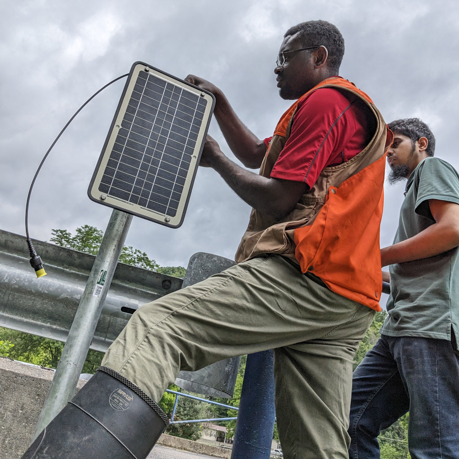
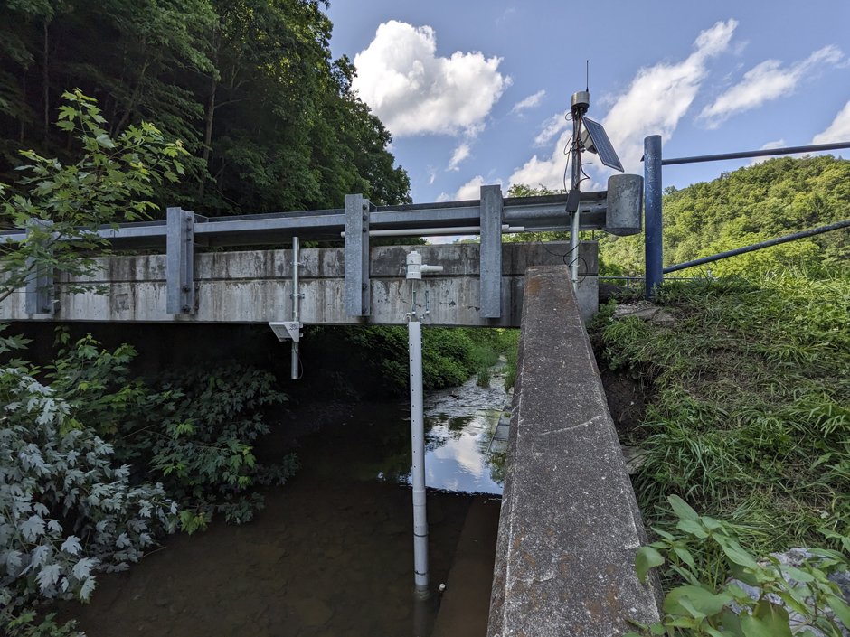
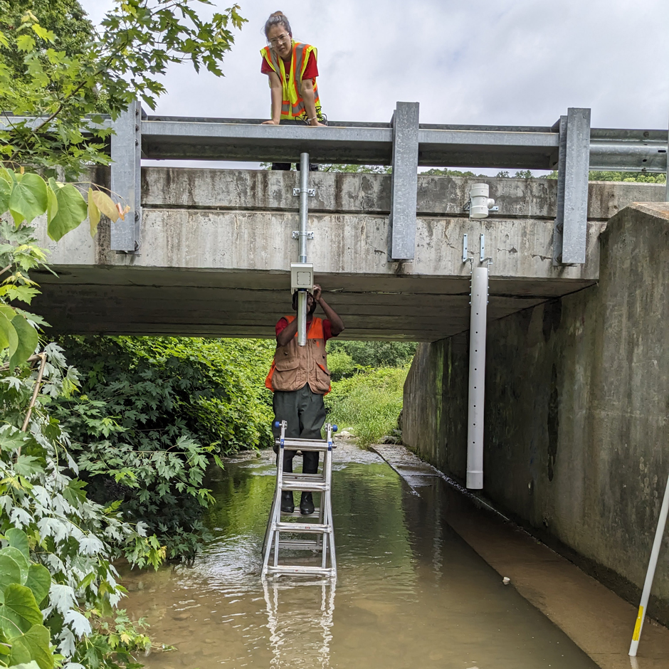
Nearly twenty monitoring stations are set up throughout Eastern Kentucky, equipped with a variety of sensing equipment that monitor changes in the waterway. More will be installed in the coming years.
A majority of these stations include a Solinst Levelogger 5 LTC or Levelogger Juniors, and a Barologger 5, which have onboard data logging. Two of these sites are also integrated with the Solinst Level Sender 5 for remote data access.
There are also several real-time flow monitoring systems equipped with a NexSens X3 Data Logger and a Geolux Non-Contact Level Sensor. One of these stations includes a YSI EXO2 Multiparameter Sonde that measures specific conductance, temperature, pH, dissolved oxygen, and turbidity.
Data from the NexSens system is streamed in real-time to WQData LIVE, where Mahoney and other community members can view data and receive alerts when flood conditions are present.
Mahoney also notes that there are several HOBO weather stations and rain gauges paired with HOBO MicroRX Stations for real-time weather data access.
This combination of water level, weather, and water quality measurement is key to understanding flood dynamics and impacts. While weather data can give a window into conditions that trigger floods and the expected hydrology, water quality measurements—specifically turbidity—document the transport of sediment.
“So with flooding, the most immediate dangers are obviously high water levels and velocities, which can pose immediate threats to life. But with big floods, there’s also a lot of sediment transport that occurs,” explains Mahoney.
He continues, “And knowing which specific tributaries are contributing that sediment is helpful, because we know that sediment is a non-point source pollutant that can cause problems with ecosystems as well as for communities.”
Influxes of sediment can clog up drinking water intakes, resulting in limited access to resources until the blockage is removed.
“Our emergency management office here in Kentucky will often see issues with drinking water following maybe four or five days behind a big flood. And so, understanding sediment transport with these sensors is a very important part of community response to floods,” adds Mahoney.
Highlighting the Community Aspect of Flood Response
Monitoring site locations are selected not only on the basis of answering the scientific questions asked under FLASH and CLIMBS, but also based on proximity to communities.
“We try to choose locations that are nearby folks in the community–places where people might be able to come and see our sites and access the data,” explains Mahoney.
Some of these sites are located near community centers or schools in order to increase community involvement and education surrounding flood monitoring.
He continues, “We really try to get community input whenever we’re choosing our sites. We want to make sure that the places that we’re monitoring are meaningful to the community.”
Local coordinators like James Stapleton, Watershed Coordinator for the Cowan Community Center, and Valerie Horn, Director of the Cowan Community Center, have been instrumental in helping Mahoney figure out where exactly to install sensors throughout the North Fork of the Kentucky River watershed.
Ensuring that the data collected by the network is accessible and understandable to the public is at the forefront of the initiative. Mahoney works with community members and advisory boards to share data via the WQData LIVE public portal, hosting educational events to teach individuals how to view the data.
Flood Research and Making a Difference
Ultimately, Mahoney and the FLASH and CLIMBS teams hope that the projects will improve public understanding and flood resilience. In particular, the data collected by the stations will be input into flood prediction models to investigate which of the many available models is best.
Improved models will not only give researchers like Mahoney and his team a better idea of flood and headwater dynamics, but also create a safer system for stream- and river-side communities in the region.
Mahoney stresses that the multi-agency and university collaboration, as well as student and community involvement, are essential to the initiatives’ success. In particular, Mahoney recognizes the efforts of Lindsey Barnes, engineering technician at UofL, Arlex Marin-Ramirez, Franklin Kondum, Ridwan Nur, Anju Thapa, Jackson Clark, and Kassidy Haynes, all graduate students at UofL.
“Everyone is so motivated to see this project come to fruition, and everyone is really on the same page that we need this monitoring, and that it can help to ultimately save lives,” he concludes.


